As the spread of COVID-19 has forced people indoors, life has become even more dangerous for women experiencing domestic violence, especially for those who are most marginalized. Not only are women experiencing this violence, but many children, who are also home from school, are witnessing and potentially experiencing domestic violence themselves. According to the UNFPA, six months of lockdowns could result in an additional 31 million cases of gender-based violence. The Metro Manila RGA COVID-19 findings (Sep 2020) also reported the following:
- There is an exponential increase in GBV risk and incidence due to COVID-19 and its interventions; a “shadow pandemic” that is severely underreported
- PNP data reported (15 March to 02 April): 391 cases of VAWC, 42 cases of rape
- There is disruption of services for VAWC survivors due to overburdened offices/facilities during COVID-19
As such, coming together to support women in this crisis is critical.
This month’s webinar is in line with CARE’s global anti-GBV campaign Together for Her, a call to action to stand in solidarity with women and girls around the world by supporting the global response against domestic violence during the time of COVID-19.
The project endeavors to address COVID-19’s “shadow pandemic” of gender-based violence in vulnerable communities in the Philippines. It will:
- Lessen GBV risk in households and provide social safety nets if women are GBV survivors through multi-purpose cash assistance;
- Raise awareness and strengthen local capacity to establish GBV referral pathways and community-based GBV monitoring; and
- Advocate for GBV services as essential, life-saving interventions in COVID-19 response on the local and national level.
In the Philippines, the Together for Her anti-GBV campaign is implemented by CARE and local partner ACCORD in Partners for Resilience communities in Malabon, Navotas, and Caloocan and with Pambansang Koalisyon ng Kababaihan sa Kanayunan (PKKK) in Salcedo, Eastern Samar, Basey, Western Samar, and Sta. Catalina, Negros Oriental.
This pamphlet was used to disseminate information and highlight the necessary information for communities and stakeholders to progress the prevention of Gender-Based Violence, particularly in the barangay level.
View and download the full document here.
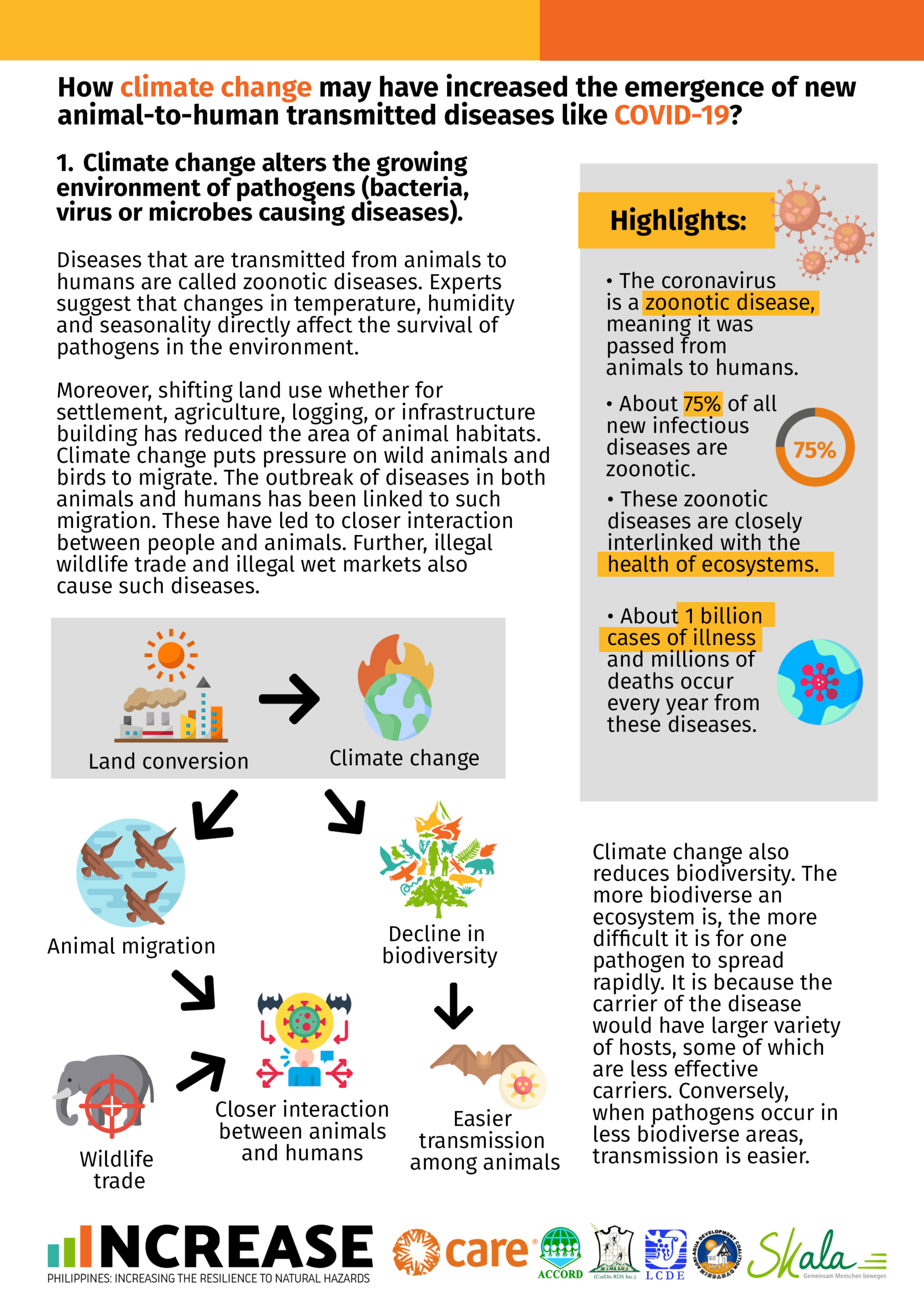
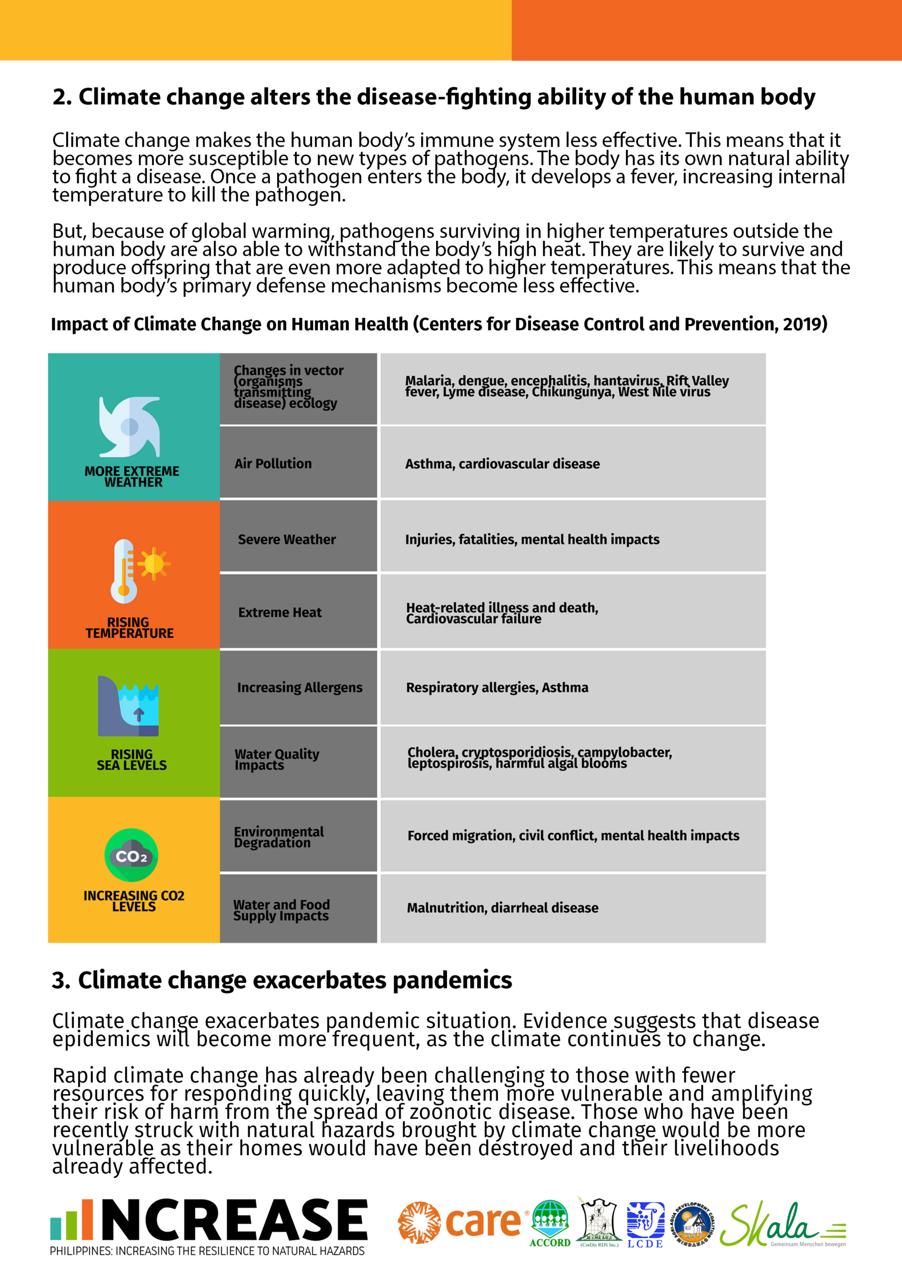
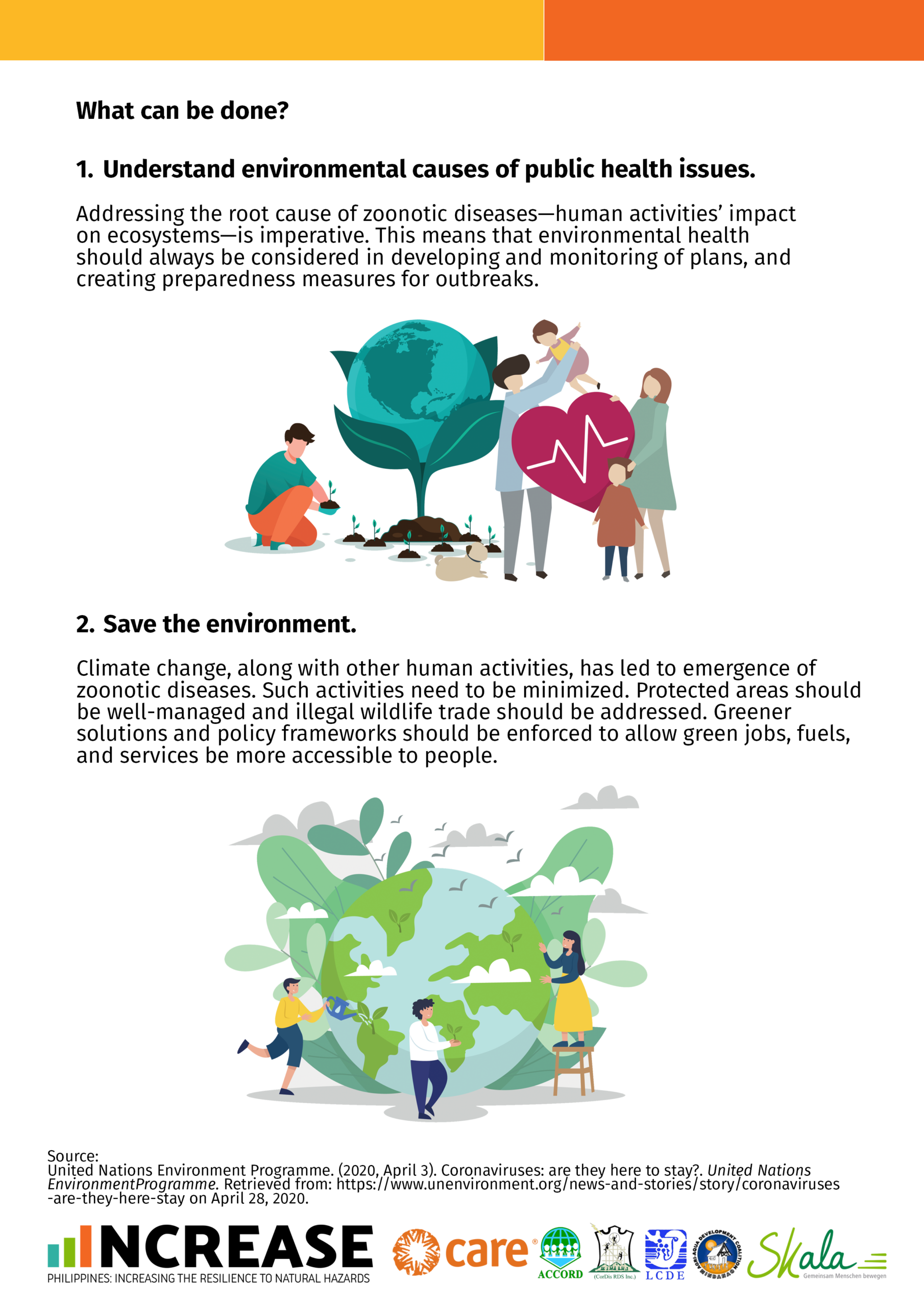
This summarizes the United Nations Environment Programme report on coronaviruses and explains the correlation between climate change and diseases. It also includes an infographic of the impact of climate change to human health and steps that people can collectively act on.
Click on the photos in the gallery below to enlarge and download a soft copy of these materails.
As the Hyogo Framework for Action (HFA) draws to an end and disaster-related loss and damage continues to increase, an important opportunity arises to shape and agree upon a successor framework that will enable management of the risks that threaten to reverse vital development gains. These risks are driven by a variety of factors (UNISDR 2013) including climate variability and change, economic and financial crises, environmental mismanagement, demographic change, rapid and unplanned urbanization, and failed governance; they disproportionately impact vulnerable and exposed low-income households around the world.
As the HFA Priority area 4 refers to disaster risk reduction (DRR) strategies integrated with climate change adaptation and lists among the “critical tasks for states” to promote the integration of DRR with climate variability and climate change into DRR strategies and adaptation to climate change, considerable effort has been made by agencies to work towards convergence of the DRR and the climate change adaptation agendas. However, despite the obvious overlap, these two agendas have evolved independently and in parallel (Mitchell & van Aalst 2008, Mitchell et al. 2010, Mercer 2010) and have faced different challenges (e.g. Schipper & Pelling 2006). In terms of practical programming, there has perhaps been some risk of “relabelling” classical DRR efforts addressing weather-related risks without consciously incorporating concerns for the change in risk patterns, extreme events and vulnerability partly induced by climate change. In addition, there has been a tendency to initiate stand-alone climate change adaptation (CCA) projects disregarding existing vulnerabilities, in effect “overstating” the adaptation aspects of the project rather than integrating adaptation measures into existing approaches, as recommended in the HFA.
Since the HFA in 2005 more compelling evidence about how climate change has – and continues to – influence disaster risk has emerged (including IPCC AR4 and AR5 and SREX). At the same time, many implementing agencies, in particular civil society organizations, have developed and tested various approaches and tools to integrate climate aspects in (participatory) assessments and planning (IIRR Cordaid 2013, CARE 2009, Wiggins 2012) and considerable effort has been made to bounce ideas and share knowledge across agencies about tools and methods for integrating changing climate risks into DRR through for example, the Community Based Adaptation to Climate Change Conferences, and Development & Climate Days held in the context of the annual UNFCCC Conference of Parties (Bachofen et al 2014, Suarez et al 2013). Through these iterations, some common denominators for climate-smart community programming have started to emerge.
Pilot projects across the world have shown that addressing changing climate and disaster risks at the local level is highly effective for building resilience. Strong capacities and robust institutions at the community level can maximize the impacts of climate-smart disaster risk reduction. Yet for this to happen, it is essential that communities and the organizations supporting them all know how to integrate changing risks into their activities.
While empowering communities and the local organizations that support them to become better at managing their risk, the disaster risk reduction community faces increasing pressure to deliver on a greater scale, and help local actors steer their development trajectories upwards. At the same time, policymakers seek clarity and guidance from practitioners on the standards to set for local climate change adaptation efforts – a crucial component of national adaptation planning. Taken together, these demands call for a simplified set of criteria to ensure community-based DRR programming, as well as broader resilience-building efforts, can guide communities and the organizations supporting them.
To address this growing demand, the Minimum Standards for Local Climate-smart Disaster Risk Reduction (hereafter referred to as “Minimum Standards”) have been developed to provide a ‘good enough guide’ to help local community leaders, DRR practitioners and policymakers ensure DRR efforts are geared to more uncertain future risk patterns induced by a changing climate. The Minimum Standards are meant to serve as a useful guide for planners and donors as well so they may ensure DRR programming is meeting CCA needs and that DRR actions are going beyond business as usual by truly addressing changing climate-related risks. Indeed, recognizing that the Minimum Standards are realistic and achievable, national strategies that consider them will be able to go to scale, also in facilitating the use of climate adaptation finance for local efforts to reduce the rising risk of disaster in a changing climate.
This paper presents the Minimum Standards for local climate-smart disaster risk reduction and details how they can help trigger action on climate change under the post-2015 HFA framework. The first section provides an overview of the Minimum Standards and their relevance for guiding climate-smart action at the community level and at the civil society organisation (CSO) level. The second section presents experience of community level application of the Minimum Standards in the Philippines, Indonesia, and India in the context of the Partners for Resilience Program. To illustrate how the Minimum Standards have been used to strengthen CSO’s capacity to become climate-smart, the third section details the experience of the Vanuatu Red Cross and suggests for this approach to be replicated by other CSOs. In addition, the process by which Australian Red Cross has expanded the Minimum Standards to include gender dimensions of DRR is presented in a final case study. The paper concludes with a discussion of the way forward for maximizing the opportunities to use the Minimum Standards to inform the development of the post 2015 HFA.
View and download the full document here.
By Merdi Jean Arcilla
Originally Written: September 27, 2014
If you want to develop your barangay early warning system for floods, it should be taken in the context of the Tullahan River basin” was the expert piece of advice that Susan Espinueva gave to the group that was seeking PAGASA’s technical assistance. That was in July 2013.
Ms. Espinueva was then Chief of the Hydrometeorology Division of PAGASA. Barangay Potrero in Malabon City was planning to improve its early warning system (EWS) as part of enhancing the community’s preparedness, and the Partners for Resilience program was keen on providing ample support.
Potrero is downstream of Tullahan River
Rain or shine, there are floods in Malabon. News on television has frequently shown Malabon with above ankle-deep flood water due to high tides even during clear skies and good weather. During the typhoon and monsoon rains, of course the situation worsens considerably.
In 2009 during Typhoon Ondoy (Ketsana), residents of Barangay Potrero in Malabon were startled that the water kept rising faster than normal and eventually reached the second floor of some homes. Some 6,000 families were affected. Some of these were trapped inside structures, in need of rescue support and emergency provisions. Three years later in August 2012, the same communities were again affected by floods due to heavy monsoon rains that lasted for several days.
The largest of Malabon’s 21 barangays is Potrero. With a population of around 54,000, it has been one of the most affected by the worst floods in the city. Sections of the barangay lie along the downstream of Tullahan River that stretches from Quezon City to Valenzuela City. Runoff starting from upstream La Mesa Dam in Quezon City, heavily silted and clogged Tullahan River and the frequent occurrence of high tides further contribute to the frequent floods in the area.
Potrero is one of the seven urban barangays where the Partners for Resilience (PfR) has been operating the program since 2011. It was specifically chosen because it is susceptible to floods and the affected populations mostly belong to the urban poor. The PfR program engages the Potrero barangay local government to enhance its preparedness for emergency response and work towards disaster risk reduction incorporating climate change and ecosystems management and restoration.
The road to September 2013
In the ensuing discussions with PAGASA, the group settled that to work on the EWS of Potrero it has to deal with the current status of EWS for floods in the river basin and the affected stakeholders. The Tullahan River basin covers Quezon City and the CAMANAVA area – the cities of Caloocan, Malabon, Navotas and Valenzuela.
All five cities contend with the problem of floods especially in the communities that lie along or are near the Tullahan River and its waterways.
While each has ways and actions to manage the risk, the general picture is that they do not necessarily link together to address the problem. There are EWS facilities that line the river at different points. These are basically water level and rain gauges. The La Mesa Dam Authority notifies LGUs and the public on the level of dam water. PAGASA consolidates the information that is generated from some of the EWS facilities and can make these available to LGUs. Pumping stations, river walls, dikes and other protective structures have been built in selected areas to protect specific segments of areas that are high-risk to floods. Each city issues alerts and warning based on information they are able to access.
“The floods are a problem caused by several factors in the river basin. Why don’t we call a meeting of the cities, concerned agencies and other groups who have a stake in drawing up solutions?” Once again, Susan Espinueva was forwarding sound guidance.
In September 2013, PAGASA and PFR spearheaded the first meeting of stakeholders to discuss issues on EWS for Quezon City and CAMANAVA. PAGASA defined the scope of the Tullahan River basin and traced the flow of floodwaters from upstream passing through the five cities and exiting at Manila Bay. It also showed the existing facilities for drawing up the river basin-wide EWS and pointed out that the work still has to be done to have an integrated EWS for the whole river basin. And this needs the participation of the various stakeholders.
The LGUs attended, all represented by their DRRMOs. Other agencies like the MMDA, DILG-NCR which issues the guidelines for the DRRM plans of LGUs in Metro Manila, NDRRMC which manages a big DRR project for UNDP, Ipo and La Mesa Dam authorities participated to share how they were contributing to the provision of information and shared experiences relating to flood risk management. The meeting ended on a positive note that the discussions would continue towards harmonizing the EWS for the Tullahan River basin.

The partnership gains momentum
The partners’ initial step was to survey the long stretch of Tullahan River, and see the river situation and the existing EWS facilities. In the debriefing, each partner also shared how they are doing flood mitigation measures through projects and programs within their geographical boundaries. The group also visited the Pampanga Flood Forecasting and Warning System to look at a model of an integrated EWS for a river basin that gathers information, processes this and issues warnings based on the result of the data analysis. One of the good insights that came out of these activities is that the participants themselves appreciate the continuing dialogues. They even proposed that for purposes of continuity and understanding, the same individuals be officially assigned to sit in these coordination meetings.
The most recent gathering they took part in was the presentation of the results of the risk assessment covering the whole Tullahan River basin. They expressed that information sharing that serves to enrich their basis of risk reduction actions are very much needed.
For Malabon and Valenzuela, a step further was taken when they concurred and got involved in the tree planting in the upstream La Mesa Watershed. The location is beyond their geographical boundaries and yet they recognize that this is a mitigation action that will definitely benefit their communities in terms of improved urban forest cover and protected watershed or source of water for the metropolis residents.
Moving forward
Let us look at other organized groups of LGUs who have the good practice of working together to reduce the risk of floods and other hazards and learn from them,” was the common call in the last gathering of these stakeholders in September 2014. It was a year after the initial meeting of stakeholders in the Tullahan river basin. The risk assessment was done by a group composed of individuals knowledgeable in history, biology and environmental science. More and more, they are convinced that they need multi partnerships and multi disciplines to proceed with a good analysis of the risk situation they are facing and hence need the same methods to forward an integrated plan or solutions to pursue in their next steps.
View, read, and download a PDF version of this article here.
By Celso Dulce, Jr.
Originally Written: October 8, 2014
The sight that greeted the rare visitor to Barangay Langaon was unexpected, and inspiring. Men and women, including some elderly, were busy repairing the hanging bridge known as Kalawahig-1. Some were erecting two concrete posts where steel cables of the bridge will be re-anchored. Some were replacing the wooden planks. Some were gathering rocks from the riverbed and piling them into an embankment that will strengthen the bridge’s foundation. Two days ago, the bridge was washed out by a flashflood spawned by typhoon Pablo (Bopha).
Typhoon Sendong (Washi) damaged the Kalawahig-1 suspension bridge that connects barangay Langaon to “the outside world.” The bridge was already in a state of disrepair prior to Sendong. The flooring was made of bamboo. The sides were unprotected and anybody, but most especially children, could easily fall into the river. The bridge was in urgent need of repair as the community could not bring their farm produce to the market, could not safely access relief assistance and basic services, and could not bring in basic commodities.
In March 2012, CARE worked with the community to undertake minor repair of the bridge, as part of the cash-for-work activity. Cyclone wires were installed on the sides of the bridge to prevent people from falling into the river. Rotting bamboo were replaced to strengthen the flooring. Community members were jubilant, feeling safer as they cross the bridge every day, to go to the market, and in general to do business with the outside world.

A follow-up CARE emergency response project provided another opportunity to further strengthen the bridge. It was built on the initiative of a local NGO, Green Mindanao, which constructed a concrete foundation for a new bridge, but could not afford complete rehabilitation. CARE provided thick steel cables, wooden planks, cyclone wire, nuts and bolts, and other materials to complete the bridge through another cash-for-work activity. In August 2012, the new bridge was completed. In no time, not only people were crossing the bridge but even motorbikes laden with produce. The bridge was affording people safe access to goods and basic services. It was also encouraging people to increase agricultural production and livelihood activities as the people can now safely transport farm inputs and farm produce.
On 5 December 2012, barangay Langaon lost its hanging bridge to a big flashflood triggered by typhoon Pablo. The news was very difficult to accept. According to Langaon residents, Ugiaban Bridge one kilometer upstream got clogged and formed a temporary dam. When this temporary dam burst, it unleashed a huge wall of water that reached up to the Kalawahig-1’s flooring. The residents of Langaon watched helplessly as a huge wall of water washed away their bridge. The Kalawahig-1 was built substantially higher than the original precisely to prevent it from being overtopped by floodwaters.
The Langaon community was able to retrieve all the bridge’s materials – the steel cables, the wooden planks, the nuts and bolts, the cyclone wires. With their meager resources, and without waiting for external assistance, the community started rebuilding their bridge.
“We appreciate very much the support we received from ACCORD and CARE and their donors. Such support enabled to rehabilitate our bridge. The damage caused by Pablo is a setback. Slowly maybe, but surely we will rebuild the bridge, because it is our bridge. More valuable than the material support we received from ACCORD and CARE is the confidence developed in us that by working together, we will be able to recover from the disasters that have affected us,” declared Barangay Chair Martin Tanio, as he showed the several kilograms of tie wire, the few bags of cement, and the few pieces steel reinforcement bars he bought using funds contributed by community members.
Kalawahig-1 was built through a project partnership amongst CARE, ACCORD and RMP, with funding support from the European Commission Humanitarian Aid and Civil Protection department (ECHO), AXA Philippines and Metrobank Foundation. Barangay Langaon is in Baungon municipality, Bukidnon province.
The people and the leaders of Langaon demonstrate the indomitable spirit of the poor and vulnerable, who aspire to make their communities more resilient. A visit to Langaon in October 2013 showed that the community, on its own, has restored the Kalawahig-1 bridge, their own bridge.
This is an updated version of the previous story “The Bridge of Resillience,” also by the same author.
View, read, and download a PDF version of this article here.
When Typhoon Monang battered the coastal village of Sabang in1993, massive swells from the ocean engulfed houses near the shore and killed scores of residents. One local recalls fleeing her home under the heavy downpour together with her cousin, and losing grip of the other girl as raging flood waters swept them away. Her cousin wasfound dead the next day. This grim episode in the villagers’ collective memory has left them fearful of news of approaching storms. Preventing such tragedies was ACCORD’s mission in Calabanga, a municipality in Camarines Sur that is home to 11 storm surgeprone coastal villages, one of which is Sabang. This was done by implementing a Disaster Risk Reduction (DRR) program complemented by an Ecosystem Management and Restoration (EMR) strategy.
This approach requires the active and meaningful participation of local communities. Empowering them to become active participants rather than victims means equipping them with the proper tools to assess their risks and vulnerabilities, and guiding them through capacity trainings and education. This will help them plan courses of action that are well-adapted to existing hazards and their own social context. Incorporating EMR into the process will augment the overall results of the program, for instance, by creating healthier ecosystems which may decrease disaster risks in both coastal and upland communities and also contribute to creating sustainable livelihood opportunities.
ACCORD supported building the capacity of residents against climate and disaster risks while mainstreaming the protection and management of natural resources in communities that are located near the shores and in upland areas. Part of its DRR program in Barangay Sabang is the introduction of mangrove reforestation as a small-scale mitigation measure to help reduce the adverse impacts of disasters in this time of anthropogenically-induced climate change.
A similar approach of rehabilitating ecosystems to complement disaster risk reduction and management was introduced in barangays and municipalities of Davao de Oro and Agusan del Sur. ACCORD and CARE implemented EMR activities such as riparian reforestation using indigenous tree species, slope erosion mitigation, and tree planting in portions of the upper Agusan River basin, and the Agusan Marsh.
Years after the implementation period of the projects described in this study – one project was launched in 2009 and the other, in 2015 – ACCORD continues to nurture ties with these communities and link them with opportunities for capacity building. The communities have also been able to sustain their EMR efforts.
View and download the full document here.
The climate outlook for June-August 2020 was based on PAGASA Climate Forum. This contains the compiled relevant climate information for INCREASE areas and are sent to each specific municipality. This can be used as a guide to plan out activities including food production so climate-related risks are reduced. This is updated every quarter.
Below you may find a gallery of photos detailing the climate outlook for the said period. There are also area-specific versions of the material. You may click on each photo to enlarge it or access the download link.


To address the confusion among Filipinos about the difference between the 2 available tests for COVID-19, this infographic (in Filipino language) was created. If you think you have coronavirus disease 2019 (COVID-19) and need a test, contact your health care provider, local pharmacy, or local health department immediately.
You may save the image below for a soft copy of this material.

INCREASE or “Philippines – Increasing Resilience to Natural Hazards” aims to aims to increase the resilience of 45,00 women and men small scale farmers and fishers, including 720 extremely poor female-headed households, to natural hazards and the effect of climate change. The project will run from 2019-2021 in different parts of the Philippines, namely 36 barangays across 8 municipalities in the provinces of Cagayan, Mt. Province, Northern Samar, and Surigao del Sur. Its project components and activities include early warning systems, alternative livelihood, and climate and disaster governance.
This paper presents the feedback of several groups of stakeholders from Caloocan, Malabon, Navotas, Valenzuela, Quezon City, and the City of Manila on the Final Report of the Manila Bay Sustainable Development Master Plan (MBSDMP).
Throughout August of 2019, CARE and ACCORD, through Partners for Resilience, conducted focus group discussions in six barangays, three cities, and two Water Quality Management Area (WQMA) bodies. The goal was to familiarize Manila Bay stakeholders with the MBSDMP and gather feedback from them to help ensure that the concerns and recommendations of those who may be affected by the master plan are brought to the fore. Participants were composed of community members, sectoral representatives, barangay and city local government units (LGUs), and members of the San Juan River System (SJRS) and Malabon-Navotas-Tullahan-Tinajeros River System (MANATUTI) WQMA.
The consultations consisted of one-day sessions per area, with two main parts: in the first half of the session, facilitators presented the fundamentals of Integrated Risk Management and the Rights-Based Approach before presenting the contents of the MBSDMP itself; in the second half, participants were divided into several focus groups to discuss and provide feedback on the MBSDMP.
In this paper, the results of the consultations are organized into:
A. General feedback on and cross-cutting issues affecting the MBSDMP
B. Specific feedback on each of the eight measures outlined in the MBSDMP
1. Issues and challenges – both internal to the MBSDMP itself and external factors that may affect its implementation
2. Good practices identified by participants (if any)
3. Current practices and future plans (if any)
4. Recommendations from participants
View, read, and download the full document here.
 The global pandemic known as the coronavirus disease 2019 (COVID-19) has affected millions worldwide. Presently in the Philippines, the number of cases continues to increase with 9.90% positivity rate and 1.85% mortality rate. The most vulnerable population is comprised of the elderly, those with comorbidities such as diabetes, hypertension, or those who are immunocompromised such as people living with HIV, as well as frontline workers in health and essential businesses.
Health system capacity has improved but continues to face challenges. The country currently ranks 20th in the John Hopkins case monitoring dashboard in terms of the country with the highest number of COVID-19 cases. The number of new cases remains variable with a recent spike following a 2-week decline. The Department of Health (DOH), however asserts that the health system has made significant progress not only in improving recovery rates and reducing COVID-19 mortality, but also in increasing hospitals’ capacity to serve suspected/ confirmed COVID-19 patients.
Currently, there is some 42.1% occupancy rate in wards, ICU, and isolation bedsfor COVID-19. Critical health facilities are now more equipped to provide better care to patients compared to during the early stages of the pandemic. However, testing and contact tracing capacity needs to be sustained to accurately
reflect the health situation. On September 2, the national government launched its official contact tracing app – staysafe.ph, while Local Government Units (LGU) also initiated individual contact tracing strategies/app in their respective communities.
The Philippine government utilized a public health-centered approach in mitigating the spread of the virus. Medical response includes strengthening health capacity by recruiting additional 20,000 health professionals, improved and expanded research capacity, and improved health care facilities and care protocols. Community quarantines include imposition of curfew, ban on mass gatherings, closures of schools or congregations, work suspension, and modified work arrangements.
 COVID-19 has resulted in severe socio-economic consequences. The response to the pandemic transmission has negatively impacted the economy. Since March 2020, more than 3.3 million workers have lost their jobs. Unemployment rate is at 10% as of July 2020 which is double the rate of 5.4% last year of the same month. The loss of livelihood and lack of income opportunities has limited the access of the poorest families to food, water, and health services, and increased their reliance on aid. Some 7.6M reported involuntary hunger due to the crisis.10 School suspension displaced learners, barred access to supplementary feeding, and increased care work for women. Moreover, the affected population articulated increased feelings of anxiety and distress due to the continuing uncertainty of the situation. The pandemic situation shows disproportionate impact of the pandemic to women, children, and the most marginalized sectors of society.
The Philippines remains at risk to disasters and climate change impacts. The country ranks 3rd in the World Risk Report of 2018 and 5th in the Climate Risk Index of 2019.12 Tropical cyclones account for the largest disaster-related loss in the country. Some 20 tropical cyclones occur in the Philippine Area of Responsibility (PAR) per year. At least 6-9 incidents make landfall causing damage to urban and rural communities. Due to climate change, recent historical data in the country show that stronger typhoons are becoming even more frequent. Degraded ecosystems also exacerbate the impacts of the hazard. Moreover, cyclones are often accompanied by concurrent hazards including floods, flashfloods, and landslides. It also interacts with seasonal and climatological changes including monsoon seasons and El Nino Southern Oscillation (ENSO) phases. The typhoon season has already started. Typhoon Vongfong made landfall in May 2020. It was the first typhoon to hit the country this year. It affected almost 400,000 individuals and destroyed shelter, livelihoods, and health facilities. Emergency response activities were complicated by the ongoing quarantine measures and social distancing protocols. The experience from Typhoon Vongfong showed the need to integrate minimum health standards to better prepare for similar hazard events.
On 14 June 2020, the Philippine Atmospheric Geophysical and Astronomical Services Administration (PAGASA) announced the start of the rainy season. The climate outlook shows that that there is more than 50-55% chance of La Nina either late October or November 2020 which may last through the first quarter of 2020. Above normal rainfall incidents can also be expected in the same period, particularly in December. Moreover, a total of 9 to 12 tropical cyclones are expected to enter the Philippine Area of Responsibility (PAR) until the end of the year. The onset of La Nina will cause tropical cyclones to form nearer land, thereby increasing the chance of landfall.
Capacities are stretched, and resources are dwindling. The whole country was placed under State of Calamity since 16 March 2020-12 September 2021.17 The protracted response due to COVID-19 has depleted resources of the government, private sector, and Civil Society Organizations. LGUs affected by the pandemic have already exhausted their Local Disaster Risk Reduction and Management Fund- Emergency Response Fund (LDRRMF-ERF) and have realigned their development funds to provide food assistance, conduct awareness-raising activities, and supplement health equipment and services. Medical and government front liners have provided continuous health and social services.
With the advent of the Typhoon season alongside the continuous COVID-19 response, there is a need to revisit plans to better manage risks and increase response capacities. Contingency plans (CP) can be reviewed to update risk assessments, integrate Infection Prevention and Control (IPC) protocols, and improve response arrangements. Other government plans including the DRRM Plans, Annual Investment Plans (AIP), and Comprehensive Development Plans (CDP) may also benefit from the review process.
The Contingency Planning Checklist is an attempt to summarize experiences from the ground into a diagnostic tool that supports the integration of COVID-19 protocols and lessons from the ongoing response into existing Contingency Plans. It is a list of recommendations across multiple sectors that can serve as an entry point in the CP updating process.